Precision agriculture has been made possible thanks to all the technologies and innovations that have been created over the past thirty years. These innovations rely on data gathered by specific tools and combined with other data to increase accuracy. They are then analysed and used as decision-assistance tools for operations and practices. A closer look at the equipment and technologies most commonly used in precision farming.
Precision agriculture uses connected objects: sensors, probes, drones, etc.
Data have to be created and fed into precision-agriculture systems. Some data are entered manually, such as observations in the field, others are fed back automatically via specific technologies. Sensors are used for so-called proximity detection, or close monitoring, in fields, stables, and tractors. Data can be sent back automatically, using technologies such as RFID (Radio Frequency Identification) chips, or live via Wi-Fi/Bluetooth or GSM technology. Data can also be collected using aerial systems such as drones, planes, helicopters, and satellites, using the Sentinel-2 network for agriculture. Indicators such as plant health, chlorophyll levels, and water stress can be detected using sensors fitted to farming equipment.
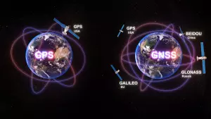
Data geolocation by satellite for agriculture
Data fusion is one of the keys to precision agriculture. Data gathered from fields and crops are often fusioned with a geolocation system. The technologies used are based on the GNSS (Global Navigation Satellite System), which are interconnected satellites. In the US, a GPS (Global positioning System) is used, in Europe, it’s Galileo. Other countries have their own constellations: Beidou for China and Glonass for Russia. For geolocation precision, signals are corrected by receivers fixed to the ground. Reference stations calculate positioning corrections before transmitting them to the vehicle via a network of geostationary satellites (e.g. the SBAS network). This is GPS - differential global positioning system: EGNOS is an example for Europe, WAAS for North America. Accuracy is increased from several metres to around 30 cm, and it is free of charge. For even mor precision, it is possible to get within 10 cm, with a subscription. When it is necessary to obtain position accuracy and, especially, repeatability over time, RTK (Real Time Kinematic) is mandatory, with the signal being sent via radio waves or UMTS signals (Global System for Mobile Communication - GSM).
Combining and analysing data to assist decision making on the farm
When data have been gathered or entered, they are saved and combined with other collected or entered data, or with a reference database. Given the volume of data to be processed, the cloud is often used for storage, pooling, and redistribution. When the mass of data has been pooled, it has to be analysed. Nowadays, this is often done by artificial-intelligence systems, such as Deep Learning, which provides new analytical and predictive capabilities, and information technology tools, like FMIS (Farm Management Information Systems). Platforms like FMIS make it easier to record farm-management activities and are increasingly evolving into decision-making tools. In the crop sector, they often include a GIS (geographic information system) function. The applications can be desktop, web, or mobile. Cloud computing is often used.
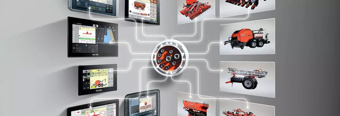
Precision agriculture in the field: tractors and connected tools
To use precision agriculture on the field, it is advisable to fit a guidance system. Agricultural machines are equipped with receiving antennas that are connected to the steering system. Inter-field application rate modulations are controlled on a terminal in the tractor cab. Steering can be assisted, semi-automatic or completely autonomous. To connect operations between machines, terminals, and management software, manufacturers and solution providers use the ISOBUS standard and language.